Wildfire Plans & Maps
Community Wildfire Protection Plans
-

CWPP Overview Sheet
Empower communities with CWPPs: Vital for federal funding & wildfire protection. Prioritize safety, resources, and action.
-

CWPP Small Group Facilitation Guide
Facilitate small group collaboration in CWPP Community Meetings with this print-out.
-

CWPP State Coverage Map
Discover CWPP State Map: Assess wildfire risk across Hawaii!
-

Kau CWPP - 2010 (Updated 2015)
Explore the updated Kau CWPP (2015) for current wildfire protection measures and strategies.
-

Kauai CWPP - Update 2016
Explore the updated Kauai CWPP - 2016 for enhanced wildfire preparedness measures.
-

Leeward Haleakala CWPP - 2020
Explore the Leeward Haleakala CWPP - 2020 for comprehensive wildfire protection strategies.
-

Molokai CWPP - 2016
Discover the Molokai CWPP - 2016 for effective wildfire mitigation strategies.
-

North Kona CWPP - 2016
Discover the North Kona CWPP - 2016: A roadmap for wildfire resilience in the region.
-

North Shore Oahu CWPP - 2021
Discover the North Shore Oahu CWPP - 2021 for effective wildfire mitigation strategies.
-

Northwest Hawaii Island CWPP - 2007 (Updated 2016)
Discover updated wildfire protection strategies in the Northwest Hawaii Island CWPP - 2007 (Updated 2016).
-

Ocean View CWPP - 2006 (Updated 2015)
Explore the updated Ocean View CWPP - 2006 (Updated 2015) for current wildfire protection plans.
-

South Kona CWPP - 2010 (Updated 2015)
Delve into the revised South Kona CWPP - 2010 (Updated 2015) for crucial wildfire readiness details.
-

South Maui CWPP - 2016
Explore the South Maui CWPP - 2016 for effective wildfire mitigation strategies and community resilience.
-

Upcountry Maui CWPP - 2016
Discover Upcountry Maui CWPP - 2016: A strategic blueprint for wildfire resilience.
-

Western Maui CWPP - 2014
Discover strategies outlined in the Western Maui CWPP - 2014 for effective wildfire mitigation.
-

Western Oahu CWPP - 2016
Discover the Western Oahu CWPP - 2016, a blueprint for wildfire resilience in the region.
-

Volcano CWPP - 2006 (Updated 2015)
Discover the revised 2015 edition of the Volcano CWPP - 2006, offering crucial wildfire planning details.
Fire History Maps
-

Hawaii Wildfire History Map
Explore Hawaii's wildfire history with our interactive map from 2002-2011, in collaboration with UH Manoa's CTAHR.
-

Hawaii Wildfire Interactive Web App
Our Hawaii Wildfire web app displays fire history, hazard assessments, community input, and census data.
-

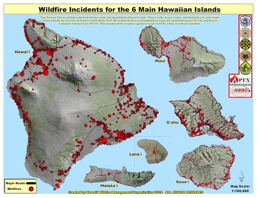
State of Hawaii Wildfire History Map (1999-2022)
Updated wildfire incident map (1999-2022) compiled by HWMO from federal, state, and local agencies' data
-
State of Hawaii Wildfire History Map (2002-2012)
USFS funded HWMO to gather fire data, collaborating with UH. Records were meticulously compiled and geo-located.
Vegetation Mapping and Results

Communities Wildfire Hazard Assessments
-

Community Wildfire Hazard Assessment and Rating Field Guide
-

Central Maui
-

East Hawaii Island
-

East Maui
-

Kauai
-

Lanai
-

Molokai
-

North Hawaii Island
-

Southwest Hawaii Island
-

West Maui
Kawaihae Wildfire Plan
