Resource Library
Island of Hawaiʻi Communities at Risk from Wildfires Assessment - 2014
Many communities in Hawaiʻi are at high risk of wildfire due to unmitigated fuels, limited community engagement, insufficient water and firefighting resources, and under-addressed pre- and post-fire planning and preparedness.
In line with its mission to protect communities and natural resources from wildfire through planning, mitigation, and education, HWMO has conducted hazard assessments for every community in the state. These assessments, coupled with the overall Communities At Risk From Wildfire Map update, will enable a more thorough understanding of wildfire hazards that can be addressed by communities, decision-makers, fire responders, and natural resource managers.
Communities at Risk Assessment map for the Island of Hawaiʻi.
Molokaʻi Communities at Risk from Wildfires Assessment - 2014
Many communities in Hawaii are at high risk of wildfire due to unmitigated fuels, limited community engagement, insufficient water and firefighting resources, and under-addressed pre- and post-fire planning and preparedness.
In line with its mission to protect communities and natural resources from wildfire through planning, mitigation, and education, HWMO has conducted hazard assessments for every community in the state. These assessments, coupled with the overall Communities At Risk From Wildfire Map update, will enable a more thorough understanding of wildfire hazards that can be addressed by communities, decision-makers, fire responders, and natural resource managers.
Communities at Risk Assessment map for Molokaʻi.
Lānaʻi Communities at Risk from Wildfires Assessment - 2014
Many communities in Hawaii are at high risk of wildfire due to unmitigated fuels, limited community engagement, insufficient water and firefighting resources, and under-addressed pre- and post-fire planning and preparedness.
In line with its mission to protect communities and natural resources from wildfire through planning, mitigation, and education, HWMO has conducted hazard assessments for every community in the state. These assessments, coupled with the overall Communities At Risk From Wildfire Map update, will enable a more thorough understanding of wildfire hazards that can be addressed by communities, decision-makers, fire responders, and natural resource managers.
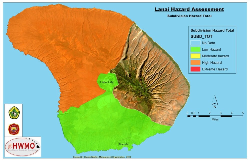
Communities at Risk Assessment map for Lanaʻi.
Maui Communities at Risk from Wildfires Assessment - 2014
Many communities in Hawaii are at high risk of wildfire due to unmitigated fuels, limited community engagement, insufficient water and firefighting resources, and under-addressed pre- and post-fire planning and preparedness.
In line with its mission to protect communities and natural resources from wildfire through planning, mitigation, and education, HWMO has conducted hazard assessments for every community in the state. These assessments, coupled with the overall Communities At Risk From Wildfire Map update, will enable a more thorough understanding of wildfire hazards that can be addressed by communities, decision-makers, fire responders, and natural resource managers.
Communities at Risk Assessment map for Maui.
Kauaʻi Communities at Risk from Wildfires Assessment - 2014
Many communities in Hawaii are at high risk of wildfire due to unmitigated fuels, limited community engagement, insufficient water and firefighting resources, and under-addressed pre- and post-fire planning and preparedness.
In line with its mission to protect communities and natural resources from wildfire through planning, mitigation, and education, HWMO has conducted hazard assessments for every community in the state. These assessments, coupled with the overall Communities At Risk From Wildfire Map update, will enable a more thorough understanding of wildfire hazards that can be addressed by communities, decision-makers, fire responders, and natural resource managers.
Communities at Risk Assessment map for Kauaʻi.
Oʻahu Communities at Risk from Wildfires Assessment - 2014
Many communities in Hawaii are at high risk of wildfire due to unmitigated fuels, limited community engagement, insufficient water and firefighting resources, and under-addressed pre- and post-fire planning and preparedness.
In line with its mission to protect communities and natural resources from wildfire through planning, mitigation, and education, HWMO has conducted hazard assessments for every community in the state. These assessments, coupled with the overall Communities At Risk From Wildfire Map update, will enable a more thorough understanding of wildfire hazards that can be addressed by communities, decision-makers, fire responders, and natural resource managers.
Communities at Risk Assessment map for Oʻahu.
Communities at Risk from Wildfires Assessment
Many communities in Hawaii are at high risk of wildfire due to unmitigated fuels, limited community engagement, insufficient water and firefighting resources, and under-addressed pre- and post-fire planning and preparedness.
In line with its mission to protect communities and natural resources from wildfire through planning, mitigation, and education, HWMO has conducted hazard assessments for every community in the state. These assessments, coupled with the overall Communities At Risk From Wildfire Map update, will enable a more thorough understanding of wildfire hazards that can be addressed by communities, decision-makers, fire responders, and natural resource managers.
Communities at Risk Assessment map for all the major Hawaiian Islands.
Hāmākua CWPP - Updated 2024
CWPPs are vital for Hawaiʻis wildfire defense. HWMO leads region updates for community safety.
CWPP Meeting Schedule
Join us at the table for wildfire learning and risk-reduction action for your region!
East Honolulu CWPP - Updated 2024
CWPPs are vital for Oʻahus wildfire defense. HWMO leads region updates for community safety.
East Hawaii Island - Community Wildfire Hazard Assessments
HWMO, in collaboration with partners, conducted a comprehensive state-wide hazard assessment, focusing on the east side of Hawaii Island, to inform CWPPs and other fire management strategies with detailed hazard ratings.
North Hawaii Island - Community Wildfire Hazard Assessments
HWMO, alongside partners, conducted a comprehensive state-wide hazard assessment, which aids fire management strategies for Hawaii Island's north region and provides detailed data for CWPPs and future initiatives.
Southwest Hawaii Island - Community Wildfire Hazard Assessments
HWMO's island-wide hazard assessment, conducted with partners, informs fire management strategies for Hawaii Island's southwest region, guiding CWPPs and future initiatives with comprehensive data.
Lanai - Community Wildfire Hazard Assessments
HWMO and partners conducted island-wide hazard assessments, leveraging expert insights and site inspections to inform fire management strategies, particularly centeral Maui, guiding CWPPs and future initiatives.
Central Maui - Community Wildfire Hazard Assessments
HWMO and partners conducted island-wide hazard assessments, leveraging expert insights and site inspections to inform fire management strategies, particularly central Maui, guiding CWPPs and future initiatives.
East Maui - Community Wildfire Hazard Assessments
HWMO and partners conducted island-wide hazard assessments, leveraging expert insights and site inspections to inform fire management strategies, particularly in the eastern region of Maui, guiding CWPPs and future initiatives.
West Maui - Community Wildfire Hazard Assessments
HWMO, with partners, completed a comprehensive hazard assessment, utilizing site inspections and expert input, to guide fire management in Maui's western region and inform CWPPs and future initiatives.
Molokai - Community Wildfire Hazard Assessments
HWMO, in collaboration with partners, conducted island-wide hazard assessments, combining site inspections and expert input to provide detailed fire environment ratings, aiding CWPPs and future fire management efforts on Molokai.
Kauai - Community Wildfire Hazard Assessments
HWMO, along with dedicated partners, conducted a comprehensive hazard assessment across Kauai County, utilizing expert-driven site inspections and fire responder input to evaluate 36 criteria per area, guiding future fire management strategies.
2018-19 Rapid Assessment of Vegetation Management Results
Wildfire's escalating threat in Hawaii necessitates landscape-level vegetation management strategies, as evidenced by HWMO's collaborative initiatives and rapid mapping assessments to mitigate hazards and enhance community resilience.


